


According to the Guangdong Meteorological Service, Typhoon Ragasa is forecast to make landfall along the coastal areas from Zhuhai to Xuwen in Guangdong on September 24 as a severe typhoon or super typhoon. After landfall, it is expected to shift towards the west.
As of 2:00 PM on September 23, cities including Shanwei, Huizhou and Dongguan have already issued red alerts, the highest level of typhoon warning. This indicates that these areas will be affected by the typhoon within the next 12 hours or are already experiencing its impact, with average wind speeds reaching or expected to reach 12 or more on the Beaufort scale and the strong winds are set to continue.
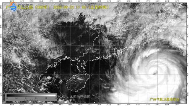
(Photo: Guangdong Weather)
In terms of storm surges, from the morning of September 23 to the morning of September 24, a storm surge of 90 to 150 centimeters is expected along the coast from Chaozhou to Huizhou in Guangdong. The coastal areas from Shenzhen to Jiangmen will see a storm surge of 120 to 250 centimeters, while the coast from Yangjiang to Maoming will experience a storm surge of 30 to 90 centimeters.
It is predicted that under the influence of Typhoon Ragasa, Guangdong will undergo a severe rain and wind process from September 23 to 25. Eastern Guangdong, the southern parts of Meizhou and Heyuan, the Pearl River Delta region, and western Guangdong will successively experience heavy to extremely heavy rainfall, with isolated torrential downpours.
On September 24, western Guangdong and the southwestern part of the Pearl River Delta will experience heavy to extremely heavy rainfall with isolated torrential downpours. Eastern Guangdong and the southeastern part of the Pearl River Delta will have heavy rain with isolated torrential downpours, while the remaining areas will see heavy rain with isolated downpours.
On September 25, the southern part of the province will have heavy rain with isolated downpours, while the remaining areas will experience moderate rain with isolated heavy rain.
Reporter | Chen Jinxia
Editor | Hu Nan, Shen He