


A newly-formed tropical storm, Typhoon Tapah, is forecast to strike the southern Guangdong coast between Zhuhai and Zhanjiang on Sunday, bringing severe winds and rain to the region.
The storm, the 16th typhoon of the year, was located over the central South China Sea on Saturday morning. At that time, it was packing sustained winds of up to 90 km/h and is expected to intensify further as it moves northwest at 15-20 km/h.
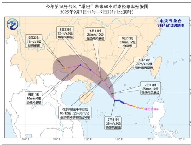
(Photo: Nanfang Plus)
Meteorologists warn that Tapah could make landfall as a strong tropical storm, with winds reaching 100-110 km/h. From Saturday night through Monday, coastal waters in western and central Guangdong are expected to experience gales of up to force 12, while inland areas brace for widespread heavy rainfall.
The heaviest downpours are forecast for the southern cities of the Pearl River Delta and western Guangdong, where rainfall could exceed 300 mm in some areas, raising the risk of flash floods and landslides. Eastern Guangdong is also expected to see heavy showers, while northern parts of the province will be less affected.
Authorities have urged residents to take precautions against flooding, power outages, and travel disruptions, as well as to avoid venturing into coastal waters during the storm.
Guangdong Weather Forecast (September 7-9)
Sept 7: Coastal counties will see heavy to torrential rain, while other areas remain mostly cloudy with scattered thunderstorms.
Sept 8-9: The southern Pearl River Delta and western Guangdong will face heavy to torrential rain, with some areas experiencing extreme downpours. Eastern Guangdong will see heavy rain, while other regions may have thunderstorms and localized downpours.
Guangzhou:
Sept 7: Cloudy, turning to thunderstorms, 25–34°C.
Sept 8: Overcast with heavy to torrential rain, 24–29°C.
Sept 9: Overcast with heavy rain, 25–30°C.
Reporter: Zeng Xiangxin
Editor: Hu Nan, James Campion, Shen He