


Screenshot of typhoon website of China Meteorological Administration
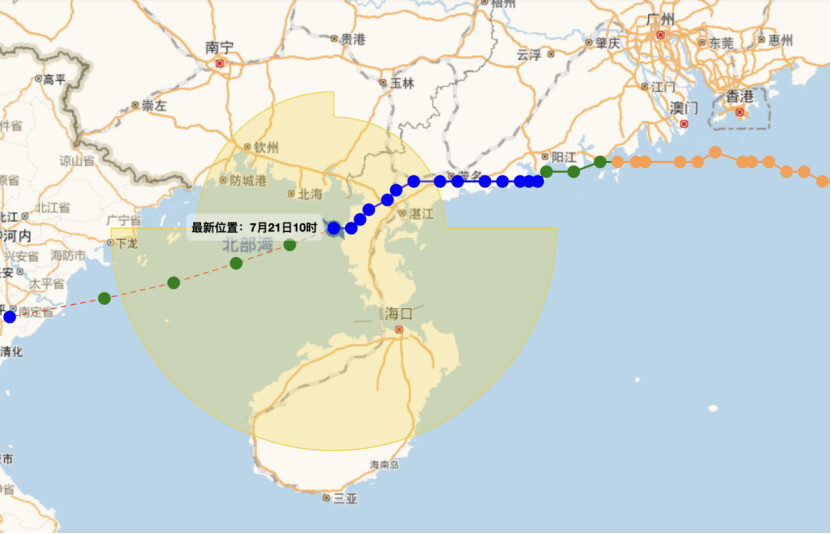
Typhoon Wipha, the sixth named storm of the year, has weakened into a tropical storm after making two landfalls in southern China and has now moved into the northern waters of the Beibu Gulf. The storm first struck Taishan, Jiangmen, on the afternoon of July 20 before making a second landfall later that evening on Hailing Island in Yangjiang. As of 10 am on July 21, Wipha's center was located over the northern Beibu Gulf, packing maximum winds of 20 meters per second (tropical storm level 8).
Despite its weakening state, Wipha is forecast to regain strength and intensify into a severe tropical storm, with wind speeds reaching levels 10-11, before making landfall along Vietnam’s northern coast on July 22.
Guangdong province has experienced widespread severe weather in recent days, with powerful winds and torrential downpours especially affecting the western and southern Pearl River Delta regions. From July 19 to the morning of July 21, winds reaching up to 15 on the Beaufort scale were recorded along the coast and at sea, with gusts as high as 56.7 m/s on Guishan Island near Zhuhai.
The storm also brought a noticeable drop in temperatures. Most cities across Guangdong saw daytime highs decrease by 2 to 8 degrees Celsius compared to July 19. The coolest temperatures were recorded in Meizhou's Dapu County at 24.1°C.
Heavy rain is expected to continue on July 21 across southern Guangdong, especially in Zhanjiang and Maoming. The province's weather will begin to stabilize from July 22 as Wipha moves away, although scattered downpours will persist through July 24.
Authorities have urged residents to remain alert to risks of secondary disasters such as flooding and landslides as rain and wind gradually ease.
Reporter: Zeng Xiangxing
Editor: Hu Nan, James, Shen He